Honolulu sits at the crossroads of active volcanism and deep-ocean tectonics. The 2006 Kiholo Bay M6.7 earthquake, though centered on the Big Island, rattled buildings across Oahu and reminded every structural engineer that distance does not guarantee safety. Seismic microzonation in Honolulu takes that reminder seriously. It converts regional hazard models into block-by-block predictions of ground motion, factoring in the city’s ancient coral fill, weathered basalt ridges, and the soft sediments of the Waikiki coastal plain. A standard ASCE 7 site class is too blunt for this patchwork geology. We use deep shear-wave velocity profiles, measured with MASW surveys and calibrated against local borehole logs, to build a site response model that reflects actual subsurface contrasts. The output is a map that tells you exactly where the 0.2-second and 1.0-second spectral accelerations will amplify, and by how much. That precision feeds directly into the structural base shear calculation, often reducing overconservatism and saving foundation costs. Honolulu’s building department reviews these studies with increasing scrutiny, and for good reason—the city’s tsunami evacuation routes and critical lifelines depend on accurate shaking forecasts, not generic assumptions.
Honolulu’s saturated Waikiki fill can double spectral accelerations compared to rock outcrop—site-specific microzonation catches that amplification before the structural design does.
Scope of work in Honolulu
Live process video
Typical technical challenges in Honolulu
ASCE 7-22 Section 11.4.8 allows site-specific ground motion analysis, and Honolulu’s complex subsurface makes that provision a practical necessity. The IBC classifies much of the coastal plain as Site Class D by default, but our microzonation work in Kakaako and Ala Moana has repeatedly identified pockets of Site Class E—softer than the default assumption—due to thick, loose coral rubble fill. An engineer who designs to a Type D spectrum over a Type E site underestimates the long-period spectral demand by 30% or more. That error translates directly into underdesigned moment frames and shear walls. The Hawaii State Building Code adopts the IBC with local amendments, and the Honolulu Department of Planning and Permitting expects geotechnical reports to justify any departure from default site coefficients. Microzonation provides that justification with defensible, measurement-based maps. Beyond code compliance, the financial exposure is real: a single post-earthquake structural retrofit in a downtown high-rise can exceed the cost of a full microzonation study by two orders of magnitude. Honolulu’s owners and developers are learning that spending on upfront seismic characterization is the cheapest insurance policy they will ever buy.
Our services
The microzonation study is the umbrella document, but two supporting field programs deliver the raw data that make the maps credible. Both are executed under the supervision of a Hawaii-licensed professional engineer with specific experience in Oahu’s volcaniclastic and coralline formations.
Site-Specific Shear-Wave Velocity Profiling
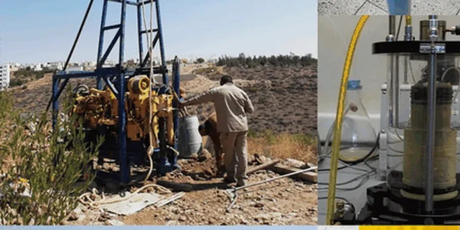
We run MASW lines and downhole PS suspension logging in Honolulu’s urban lots to measure Vs directly. The profile feeds 1D site response analysis in DEEPSOIL or Strata, producing the amplification factors that populate the microzonation GIS layers. Every profile ties to a logged borehole for lithologic control.
Liquefaction Hazard Mapping
Honolulu’s coastal water table and coral fill create liquefaction risk that standard maps miss. We compute LPI and lateral spreading displacement across the site, using SPT blow counts and fines content from our lab. The maps highlight zones where ground improvement or deep foundations become mandatory.
Questions and answers
How much does a seismic microzonation study cost for a typical Honolulu site?
A complete microzonation package—including field geophysics, borehole drilling, site response modeling, and GIS deliverable maps—generally ranges from US$4,240 to US$16,040 for most Honolulu parcels. The final figure depends on site area, number of measurement points, and the depth of the velocity profile required. A small lot in Kaimuki with one borehole and one MASW line falls toward the lower end, while a multi-acre Waikiki development requiring several deep boreholes, crosshole testing, and 2D amplification maps approaches the upper end. We provide a fixed-price proposal after reviewing the site plan and any existing geotechnical data.
How long does a microzonation study take from field work to final report?
Field work in Honolulu typically requires 3 to 6 working days for geophysical surveys and drilling, depending on site size and access constraints. Laboratory cyclic testing adds 2 to 3 weeks. Site response modeling and map production take an additional week. The full report, stamped by a Hawaii-licensed engineer, is usually delivered within 4 to 5 weeks of mobilization. We coordinate with the Honolulu DPP early if the study will support a building permit submittal.
Does Honolulu’s building code require a site-specific seismic study?
The Honolulu building code, based on IBC 2021 with Hawaii amendments, requires a site-specific ground motion analysis when the structure is assigned to Risk Category III or IV and is located on Site Class D, E, or F. Many design teams also opt for microzonation voluntarily on large projects to refine the design spectrum and reduce conservatism in seismic detailing. The Honolulu DPP geotechnical reviewers are familiar with microzonation submittals and expect ASCE 7-22 Chapter 21 compliance.
What is the difference between a USGS seismic hazard map and a microzonation map?
The USGS map provides regional rock-outcrop hazard at a 2 km grid spacing—too coarse to capture Honolulu’s sharp geologic transitions between basalt ridges, alluvial valleys, and coastal fill. A microzonation map measures site-specific shear-wave velocities and soil layering directly, then computes amplification factors that account for local resonance and impedance contrasts. It resolves hazard at the parcel scale, not the regional scale, and is the basis for a defensible site-specific design spectrum under ASCE 7.
Can a microzonation study help reduce foundation costs?
The reference range for this service in Honolulu is US$4.240 - US$16.040. The final price depends on the project scope and volume.