The ground beneath Waikiki and the slopes of Manoa tell two completely different stories. Waikiki sits on coastal sediments and fill over former wetlands, where saltwater intrusion drives resistivity values down below 5 ohm-m. Manoa, on the other hand, rests on weathered basalt and colluvium from the Koolau Range, often exceeding 100 ohm-m in drier pockets. That contrast matters when you need to map bedrock depth, locate voids, or trace a plume. Our electrical resistivity approach uses a 4-electrode array and Vertical Electrical Sounding to read these contrasts directly. Honolulu projects demand this level of detail because the volcanic geology changes fast—sometimes within a single buildable lot. We have run profiles across Kakaako brownfields where man-made fill masks old marsh deposits, and across ridgeline properties where basalt weathering creates hidden cavities. For deeper investigation, the MASW survey provides a complementary shear-wave velocity profile that helps us correlate resistivity layers with stiffness boundaries, which is critical when columnar basalt is suspected beneath the site.
Resistivity data in Honolulu often reveals what standard drilling cannot: the lateral continuity of basalt flows and the precise boundary where fresh water meets salt.
Scope of work in Honolulu
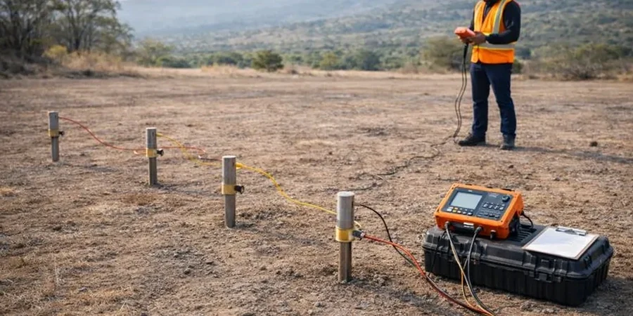
Typical technical challenges in Honolulu
A mistake we see repeatedly on Honolulu jobsites is assuming that one borehole log represents the entire foundation footprint. On a hillside in St. Louis Heights, a contractor placed footings based on a single boring that hit competent basalt at 15 feet—but the resistivity profile run after settlement appeared showed a buried lava tube just 20 feet away, with a void zone that the original investigation had completely missed. The cost of that oversight ran into six figures in remedial underpinning. Electrical resistivity is not a replacement for drilling, but it provides the lateral coverage that point-source methods lack. Combining VES with targeted borings gives you a 3D understanding of the subsurface. We have also seen projects where unanticipated groundwater perched on a clay-rich ash layer went undetected until excavation flooded. A simple VES sounding would have identified the low-resistivity saturated zone early in the design phase.
Our services
Our Honolulu resistivity services cover the full range of needs from preliminary due diligence to detailed geotechnical correlation. Each survey is configured for the specific geology and project objective.
Vertical Electrical Sounding (VES) Profiles
1D resistivity depth soundings using the Schlumberger array to map layer thicknesses and resistivities at a single point. Ideal for estimating bedrock depth, identifying the freshwater-saltwater interface, and calibrating with borehole data.
2D Electrical Resistivity Tomography (ERT)
Multi-electrode profiling with dipole-dipole or Wenner arrays to produce continuous cross-sections. Used for cavity detection, plume mapping, and tracking lateral variations in weathered basalt profiles.
Combined Geophysical & Geotechnical Correlation
Integrated package where resistivity data is correlated with SPT borings, CPT soundings, and laboratory testing to build a solid ground model. Particularly valuable for deep excavations and foundation design in heterogeneous volcanic terrain.
Questions and answers
How much does an electrical resistivity survey cost in Honolulu?
For a typical VES sounding or a short 2D resistivity line on Oahu, project costs usually range between US$610 and US$1,180 depending on the depth of investigation, number of electrode expansions, terrain access, and whether data inversion and interpretation are included. Larger 2D tomography lines or multiple VES points increase the scope and are priced accordingly. We provide a detailed proposal once we understand the site conditions and project objectives.
How deep can electrical resistivity surveys investigate in Honolulu's geology?
Depth of investigation is controlled by the maximum electrode spacing. With a Schlumberger array, the rule of thumb is roughly one-sixth to one-tenth of the total spread length. Practically, in Honolulu we have achieved reliable readings to 100 feet and deeper where basalt is not excessively fractured and surface access permits long spreads. In coastal zones with conductive saturated sediments, depth penetration is more limited because current dissipates in the low-resistivity near-surface layers.
Can VES detect lava tubes and voids under a property?
Yes, lava tube detection is one of the most common requests we handle on Oahu. Voids in basalt present as high-resistivity anomalies within a moderately resistive host rock. A single VES sounding can indicate a potential cavity, but 2D resistivity tomography is far more effective because it shows the lateral extent and approximate geometry of the void. We typically recommend combining resistivity with MASW or seismic refraction to confirm the anomaly with a second independent geophysical method.